Quest for the Four Fountains of Tibet

The confusion between sacred and actual geographies may be baffling to the scientist and the explorer, but they are the spiritual food of pilgrims.

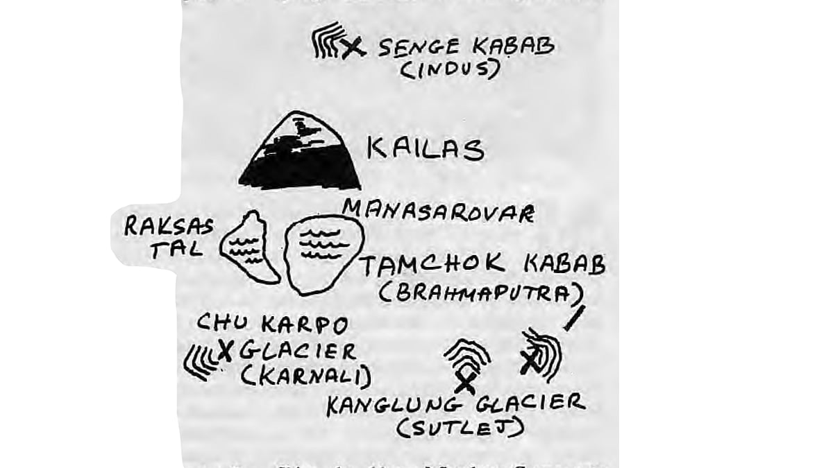
Mount Kailas, in the southwestern corner of Tibet, is regarded as the centre of the universe by millions of people. It is identified as the physical manifestation of the mythical Mount Meru, the axis mundi of the Indic religions. From Mount Kailas, or Kang Rimpoche as it is called in Tibetan, spring four great rivers, the Brahmaputra, Sutlej, Karnali and Indus. Like Mount Kailas, each of the rivers is heavily steeped in legend. In the Indo-Tibetan Chakravala cosmology, the universe is divided into four quarters or continents. Each quarter is fed by a lifeline or river which links it with Mount Kailas, the primordial fountainhead of creation. Through long mythological association, the quartet of lifelines has been identified as these four great river systems.

Having travelled and researched in the Himalaya for many years, I felt that a trek to the sources of the four rivers would be a prefect recapitulation of my peregrinations. It was an extremely rewarding journey, but the logistics, distances and paucity of detailed maps made it a challenging one. Since I could afford only the expenses of transporting myself across the wilds of Tibet, I could not rely on hired motor vehicles, guides, staff or support facilities of any kind. I had to be fully self-reliant and be prepared to travel a couple of thousand kilometres on foot over the course of many months. There was also a lack of detailed information on the sources of the rivers. The annals of Sven Hedin and Swami Pranavananda's landmark book Kailas Mansarovar helped but are incomplete and ambiguous in terms of precisely how to reach the sources. Moreover, the best topographical maps I could procure in the United States were the 1:560,000 technical aeronautical charts and the 1:1,000,000 Operational Navigational Charts of the relevant areas which are rife with erroneous and inconsistent data.

The Way of the Pilgrim

These obstacles could have dispelled my long – standing dream had I not adopted the method of the pilgrim. .A pilgrim travels to a place of spiritual power for purification, sanctification, discipline, or knowledge. The pilgrim's vital support is his or her deep abiding respect and faith in theobject of the pilgrimage. The code of conduct for the pilgrim is modest, temperate and dignified behaviour— a behaviour worthy of the spiritual quest. Most crucially, the constant companion of the pilgrim is prayer. Fortunately, the latter-day pilgrim has many examples throughout the history of Himalayan pilgrimage of people worthy of emulation.

The practical realities of pilgrimage are of as much concern as its philosophical basis. I understood the vital importance of striking a balance with the forces of Nature by trying to live in harmony with them. The hallmark of such harmony is that no discernible trace of the struggle is left on the land. This, in short, is the environmental ethic of nonviolence.

Once Thad achieved a working resonance with Nature, the next most important step of my journey was to attune myself to the cultural beliefs regarding the sources of the rivers. My elementary understanding of the Tibetan languages, religion, customs and traditions greatly increased my chance of success. I assumed that people living near Mount Kailas, or one of the river sources, would be imbued with some of their qualities, and that trying to become part of the cultural landscape would help me benefit from the qualities and power of the pilgrimage places.

Cultural Landscape

Together, the holy mountain and the four rivers that spring from it form a vast, geographical mandala that has profoundly affected the cultural universe of Himalayan peoples. This fact is demonstrated by the wide, non-sectarian appeal that the region holds for Himalayan peoples. Although the mythological and intellectual import of Mount Kailas varies from religion to religion, its central focus is undisputed. It is as if at the nexus of the spiritual world disparities and differences lose their significance and are absorbed by a greater unity. Seen from this perspective, Mount Kailas, Mansarovar and the four springs become the totem of universal understanding. I believe this to be the foundation for the irresistible attraction Mount Kailas holds for people.

The four great rivers and their tributaries drain two-thirds of the total area of the Great Himalaya. Their catchment areas include Kashmir, Himachal Pradesh, most of Nepal west of the Kali Gandaki drainage, parts of Sikkim, Bhutan, Arunachal Pradesh and Tibet. What is more remarkable is that the sources of these rivers lie within a 100 km radius, nowhere else on earth are the fountainheads of so many great river systems in such close proximity. In keeping with this geocentrism are the cultural and ecological diversity of the region. The four springs all fall under the jurisdiction of the Ngari prefecture and are contained in the Burang and Gar counties. At various times in history, the region was known as Nagri Kor Sum, Zhang Zhung, and perhaps Drushal and Uttarkhand.

The Lion's Crib

The Indus, called the Senge Tsangpo or Lion River in Tibetan, arises from the Lion Spring (Senge Kabab), 45 km north of Mount Kailas which was the first source I visited in September 1986. I reached it by following the circumambulatory trail around Mount Kailas as far as Diraphuk Gompa. I then diverged from the main pilgrim trail and continued up the Lha Chu valley to eventually cross the flat-topped Tshesti Lachen La. Continuing north, I descended the Tshesti Lachen valley past a number of cobalt-blue tarns and drokpa encampments to the Indus river valley. I followed the Indus eastward until I came to a bifurcation in the river.

I pressed on up the left fork, or Munjam Chu, which generally flows in a S.W.S. direction. Eventually, three days on from Diraphuk Gompa, I made it to the source of the Munjam Chu, one of many rivulets flowing off the steep slopes of the Kailas range. This is the actual source of the Indus, as are the headwaters of the Longdhep and Bokharrivers. Together, the Bokhar, Longdhep and Munjam produce the infant Indus. Each effluent in terms of volume and character seems as important as the others.

Above the rivulets and myriad springs forming the Munjam Chu lies a pass giving access to a freshwater lake, almost 15 km long and to the south, one ridge away from the source of the Indus. Over the next couple of days, I followed the lake around to its eastern edge. I traversed an extremely high pass back to the Tsheti Chu drainage. To this day I can only wonder why Swami Pranavananda, in his description of an alternative route to the sources of the Indus via the Topchenla and Longdhep Chu. did not mention this huge lake whose perimeter I traced. The lake basin was totally uninhabited when I arrived. The drokpas must have already vacated it if it is a summer resource.

When I encountered the bifurcation in the nascent Indus, I opted to explore the Munjam Chu. Had I followed the northwest fork, the Bokhar Chu, I would have discovered Senge Kabab, the ritual source of the Indus, a sacred spring heralded by Math stones. Having missed this sacred water source, I resolved to visit the ritual as well as the geographic sources of the other three rivers.

Whence the Sutlej?

The Sutlej is designated the Langchen Tsangpo, or Elephant River, in Tibetan. It was not until the summer of 1992 that I found the opportunity to resume my exploration of the four sources. Again I travelled fully self-sufficient with a 40 kg pack containing Tibetan precious medicines and sacramental substances to offer local Drokpas.

 This time Bikas Giri, a young Nepali sadhu, accompanied me. We began our trek on 29 July, from Darchen at the foot of the holy mountain. We hiked over the Barga plain the first day, and then clockwise around the pristine Mansarovar, the lake which pilgrims believe is the emanation of pure mind or substrate of creation. On reaching Seralung Gompa on the western shores of the lake, a lama called Konchok Shiva kindly informed us of the route to complete the trek.

Bikas and I decided to go up the Tag Tsangpo river, the largest of Mansarovar's tributaries, from its mouth rather than try a short cut from Seralung Gompa. After two days of hard walking, blown by squalls, we reached two sacred springs. One was Chumik Thongtrol, associated with Ling Gesar Gyalbo, the epic hero of Tibet. According to the Nyingma lama, Chimchol Dorje, and other native drokpas of the region, Chimik Than. gtrol was born of the tears shed at that spot by Ling Gesar Gy albo 's horse. According to thelegend, the horse wept in weariness after a long chase to destroy the black yak demon, Ayakawa. There are three koras or circiunambulations around Chumik Thongtrol, the Nangkor, Zekor, and Barkor. Each kora bestows a different empowerment on pilgrims and is marked by different sacred signs. The Zekor imbues the pilgrim with the grace of Tamin/ Hevajra, the horse-headed tannic god.

The Ganga Chumik is the companion spring of Chumik Thongtrol. Mani stones and prayer flags similarly herald its source. Confusingly, the Ganga Chumik is sometimes referred to as Langchen Kabab, the Elephant spring, ritual source of the Sutlej. Konchok Shiva, the abbot of Seralung Gompa says Ganga Chumik and Langchen Kabab are one and the same, while the eminent Ngari scholar, Kangriva Choying Dorje, says they are different. He takes the view that Langchen Kabab should be identified as the sacred springs located near the recently rebuilt Dulchu Gompa. The springs of Dulchu lie halfway between Uarchen and Moiner on the banks of the Sutlej, more than 75 km from Chumik Ganga. Swami Pranavananda compounds the confusion by stating in table XXV of his itineraries that the spring at Dulchu is Langchen Kabab while designating Chumik Ganga as Langchen Kabab on his map of the region. Evidently there was a question in the mind of the late Swami as to what actually comprises the ritual source of the Sutlej. Perhaps Chimchok Dorje, an important local Ngakpa, is correct when he says that the ritual source of the Sutlej is neither spring. Geographic incongruencies in Tibet are common and sometimes unresolvable. At this time one can only conclude that the Sutlej has various ritual sources.

The geographical sources of the Sutlej should be far more straightforward. Yet, even here, discrimination is required. The Rakas Tal and Mansarovar are alternatively chosen as the source of the Sutlej. Nevertheless, its genetic or ultimate source is far to the east of Mansarovar, at the headwaters of the Tag Tsangpo river. Approximately 35 km upstream from the twin sacred springs, the Tag Tsangpo issues out of the snout of the Kanglung Glacier resting on the lap of the Tsangla (Sanskritised to Changla) Himal. Below the glacial moraines of the Kanglung is a summer camp site occupied by drokpas between June and early September. Slightly west of the Kanglung, also in the Tsangla Himal, is Lalung, a less important glacial source for the Tag Tsangpo, and by logical extension the •Sutlej river.

The Horse's Ears

In Tibetan mythology, the Brahmaputra is referred to as the.Tanichok Tsangpo, or Horse River. Just east of Kanglung is the Tag La, a series of ridges dividing the Sutlej drainage basin from that of the Brahmaputra. There are three possible sources of this great river. The least important, in terms of volume, is a lake called Tamalung Tso. It is located just north of the Tag La. Tamalung Tso is really a string of smaller lakes which drain into the Brahmaputra.

The second larger source of the Brahmaputra is a glacier at the head of the Dungdung Chu valley. In his book, Swami Pranavananda calls the valley Angsi Chu, yet I found no local reference to the use of this name. Undoubtedly, the largest and most important source of the Brahmaputra is the Tamchok Kabab Kangri glaciers, the Horse Spring. Incidentally, this is the only case where the actual and ritual sources match. Tamchok Kabab is located 35 km due southeast of Tamalung Tso in the Tsangla Himal. Swami Pranavananda in Kailas Mansarovar states it derives its name from the Tamchok Kangri and the nearby Chimayungrung glaciers, which are likened to the ears of a giant horse. The etymology of Tamchok leaves little doubt that it is derived from the Tibetan words for horse and ear. However, the interpretation of the information 1 had at hand differs with the Swami's interpretation. According to a local drokpa, the pyramidal mountains flanking the Tamchok Kangri Glacier are the ears of the horse and not the glaciers themselves. Furthermore, the plains in front of the glacier form the nose of the mythological horse. Perhaps Swami Pranavananda's interpretation and the one I received are both correct? Is sacred geography as much a dimension of the landscape as it is of the mind?

On a more mundane level, the joining of the watercourse originating from both the Tamchok Kangri and Chimayungrung glaciers lead to the Chimayungrung Chu. Chimayungrung is composed of two Tibetan words meaning sand and swastika. The drokpas of this place told me the name represents a swastika manifested from earth, self-formed and primordial. The confluence of the Chimyungrung Chu and Dungdung Chu creates a lake called Rabgye Tso. Rabgye Tso was known as Brahma Kund to Bhotia traders according to Swami Pranavananda. The river below Rabgye Tso is referred to as the Martsang or Yarlung Tsangpo, or the Brahmaputra proper. Two years ago, Chimchok Dorje, the Ngakpa, rebuilt a chorten at the edge of Rabgyo Tso to mark the beginning of one of the world's longest rivers.

One of the most interesting cultural landmarks found at any of the four sources is at Tamchok Kabab. It consists of a series of cubicles built around black boulders the size of houses. The structure is flanked by cairns topped by white stones. This monument is called Bonpo Gompa. The drokpas say it is the ancient place where the semi-mythic founder of Bon, Miwo Shenrab, practised religion.

The Peacock River

The Karnali is the Mapcha Tsangpo or Peacock River. The source of the Karnali lies 85 km south of Mount Kailas. Until the 19th century, the Western world was led to believe that the fourth river originating from near Mt Kailas was the Ganga. However, although the Ganga begins only 225 km from Mount Kailas, its source, Gomukh, is on the south side of the Himalaya. The Mapcha or Karnali and its tributaries drain all of Nepal west of the Kali Gandaki with the exception of the Mahakali catchment area. I began the trek to the source of the Karnali on 17 August 1992, from Burang Dzong, the entrepot bazaar near the point where Tibet, Nepal and Indi a meet. I hiked to the source up the Mapcha Tsangpo valley via the village of Kardung and the pastoral encampments of Krekopar, Nama Korkor and Tarachen. There is also an alternative route to Tarachen via Harkang and the Ur la. I returned to Burang via this alternative route. Upstream of the Tarachen on the edge of a shelf above the Karnali river is Mapcha Chu Ko, the ritual source of the Karnali. It is a beautiful, full spring with exceptionally sweet-tasting water. The water running down from the springs represents the peacock's mouth. The gulley above the spring is likened to its long neck, and the ridges rising above the shelf are said to resemble its wings. The best way to visualise the sacred geography is to imagine a colossal peacock swooping down from the heavens with its head nearly touching the Karnali valley.

The geographical or actual source of the Karnali is two more days' walk from Mapcha Chu Ko. This disparity goes virtually unrecorded in most of the literature, religious and exploratory, pertinent to the region. This indeed is an import ant key in unravel ling the riddles of Tibetan geography, and is crucial in delineating physical geography from sacred geography. Beyond Mapcha Chu Ko, there are two main tributaries originating off the flanks of the Central Himalaya.

In the first of these tributaries against the ramparts of the Himalaya are the ruins of Namkha Khayung Dzong, the celestial Eagle Fort. Namkha Khyung Dzong was the second largest gompa in Ngari before the Cultural Revolution (the largest was Simbaling Gornpa, in Burang). The Nyingma establishment belonged to the Degel Rimpoche subsect, which practices Ati yoga. Namkha Khyung Dzong was only in existence for 50 years, but during that time represented a significant new element in the sociopolitical makeup of the Nyingrna sect. The cut rent head of the Namkha Khyung Dzong is Shiva Lodoe Rimpoche who resides at Bansbari, Kathmandu.

Where Black Meets White

Passing the sacred main Himalayan tributary after Mapcha Chu Ko, the Karnali splits into two branches of equal size. Which one led to the source? The easterly fork is called Chu Napko, or the Black River. Chu Napko has a non-glacial trans-Himalayan origin. The northerly flowing fork is called Chu Karpo, the White River. It issues from a glacier on the north side of the main axis of the Himalaya. This glacier is about 35 km from the confluence of the Black and White rivers.

I opted to pursue the Chu Karpo to its headwaters. Its glacial origin and longer length led me to determine that it, and not the Chu Nakpo, is the actual source of the Karnali. Is the Chu Karpo glacier the one with Lampiya Pass surmounting it, an old Bhotia trade route? I had no way of knowing, and there was not another human being for many miles around from whom I might have inquired.

From my explorati ons of the Fabled Four Mountains of Tibet I conclude that a number of cultural and geographical questions pertaining to them are as yet unanswered. There is much ground work to build on the findings of Sven Hedin and Swami Pranavananda. Maybe too hastily have cartographers filled in this area, one of the last terra incognitas on the planet. Briefly, subsequent explorations to the region should attempt to clarify or answer the questions given below.

Unanswered Questions

  1. What is the exact geographic configuration of the three uppermost feeders of the Indus, the Bokhar, the Longdhep, and the Munjam rivers, and how do adjacent areas interconnect with them?
  2. What and where is Langchen Kabab?
  3. What is the name of the glacier at the head of the Karnali?
  4. What is the relationship between the uppermost tributaries of the Karnali and which should be attributed as the actual source of the river?
  5. What are the Nagri drokpa oral traditions relating to the Fabled Four Mountains? This is nearly untouched cultural ground.
  6. Can any light be shed on the historical ritual significance of the Tamchok Kabab Bonpo Gompa?
  7. What more can be learned about Namkha Khyung Dzong?
  8. Do the sacred sources of the four rivers have medicinal properties as the Tibetans claim?
  9. Why is Chumik Thongtrol one of Ngari's only Ling Gesar Gyalbo sites when many exist in nearby Ladakh and Baltisthan?

J.V. Bellezza does environmental consultations for the Himachal Pradesh state government and for the North West Frontier Province in Pakistan. He also leads treks.

Loading content, please wait...
Himal Southasian
www.himalmag.com