Map of India taken from Report on the last Viceroyalty, Rear-Admiral The Earl Mountbatten of Burma, 22 March to 15 August 1947. Photo: The British Library

Nations out of fantasy

Modern Southasia’s ‘cartographic anxiety’ is traceable directly to colonial-era machinations. It is time for the region’s people to make their own decisions about how to define their territories.

What the map cuts up, the story cuts across.

– Michel De Certeau

That myths construct nations has by now become a post-truism. In the 60 years since August 1947, most Southasians have realised, and perhaps begun to move beyond, this maxim. The Partition of the Subcontinent and the Independence of India and Pakistan inaugurated both triumph and tragedy in such callous proximity that the story of one remains incomplete – and, in fact, becomes misleading – without the mournful narration of the other.

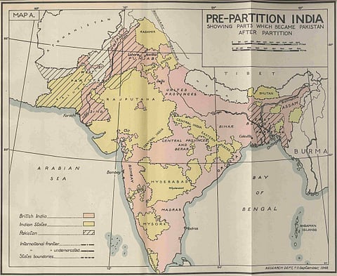
Almost every genre of Southasian public discourse – political debates, textbooks, films, fiction, academic and popular histories – has captured the vicissitudes of the era that culminated in August 1947. Such representations and analyses have remained largely restricted to the roles of prominent personalities, the unhealthy evolution of religious communalisms, and constraints produced by political exigencies or structural factors. Of late, novel perspectives have been offered by academic historians and political scientists who have focused on the logic of the colonial administrative machinery and its impact on the process of nation-state formation, in order to explain the Partition. Undeniably, existing accounts of the Subcontinent's painful passage from a colony to a collection of postcolonial nation states are emotive, rich and controversial. However, little attention has been paid to the process through which the Subcontinent's territory was politically organised under the British rule, and the impact this may have had on the events of 1947, and since.

A focus on geographical territory to explain events such as Partition and its consequences does not tend to excite the popular imagination. This is because cartographic depictions of politico-physical entities – the Indian state, say, or the Southasian region – do not reveal the dense social-cultural networks that punctuate the space they represent. Rather, they are essentially clean visual depictions of the myth of the nation state. Territory is meaningless without people, their cultures and the norms by which they are governed. Yet, it is indispensable for a modern political community to exist and be recognised. Not unlike other regions, territorial exclusivity is the defining feature of nation states in Southasia. This ritual of European modern faith was adopted by the starved and violent children of Partition – India and Pakistan – in order to shield their fledgling identities from collapse. It is unnecessary to reiterate the sordid tale of the India-Pakistan rivalry over the past 60 years. Relevant for us is their unabated obsession with territories – and the need to acknowledge that the situation did not have to be so.

Maps and oxymorons

The European cartographic endeavour in Southasia that began with the onset of mercantile colonialism followed its cue from phantasmagorical representations of the land by visiting travellers and missionaries in the service of capital and Christianity. It was this dual concern that also launched global territorialism in 1492, when Christopher Columbus 'discovered' America while in search of India. Global territorialism was an assortment of strategies, to use historian David Ludden's words, aimed at making "the whole earth into a place that can be controlled, managed and fought over." It took only six more years for this enterprise to reach Calicut in 1498, and the sea route to the Subcontinent was also 'discovered'. This was the beginning of an age when Europe monopolised 'real' time for itself, relegating the rest of the world to the backwardness of the past and assuming the longest-borne 'burden' in the history of humankind. The most lucrative chapter of this global territorialism was opened in the Subcontinent in 1757.

The victory at Plassey trans-formed the traders of the East India Company into the rulers of the land (see accompanying story, "Not remembering Plassey"). Albeit for the sake of economic exploitation, it quickly became essential to map the territory that the coloniser had come to control. Six years after Plassey, the English surveyor James Renell began mapping the subcontinental space, relying heavily on Ain-i-Akbari, the gazetteer compiled during Emperor Akbar's reign. In the ensuing years, the British endlessly mapped, surveyed and carried out censuses. As the paraphernalia of modern statehood began to take root, an incipient notion of territorial sovereignty emerged. It was an exercise in state-making to which the people of the Subcontinent were unaccustomed.

Immediately preceding the British conquest of the Subcontinent, the Mughal Empire and the Maratha kingdom had developed fairly sophisticated, yet essentially non-European, territorial polities. Both delineated the territorial limits of their rule and exercised reasonably exclusive juridical control within them. Pre-colonial empires and kingdoms of the Subcontinent were not organised along strictly defined borders – a neat separation of the 'inside' from the 'outside', delineating the state's legal personae from aliens. They did not exhibit the hard edges of modern states. Moral sovereignty of communities preceded territorial exclusiveness. In sum, they differed significantly from the post-Westphalian European nation states in how they defined the legal-political relationship between territory and people. This political organisation of space – or territoriality – operated outside the ambit of the European global territoriality, which was being pursued with gunpowder and the Bible. Colonial conquest disturbed the trajectory of this local territorial culture.

The model of nation-statehood that was eventually grafted onto the Subcontinent was twice removed from its Westphalian origin. First, the 'colonial sovereignty' of the Subcontinent was not the same as its European variant. In fact, the phrase betrayed its oxymoronic potential. Second, the impact of European territoriality was critically infiltrated by persisting spatial patterns of pre-colonial polities. This fusion resulted in a locally articulated, contentious institution of sovereignty. Within a century of 1757, the construction of a colonial Indian state was propped up by maps, museums and censuses. Consolidating authority over the heartland of the Subcontinent, however, was easier than fashioning the frontier areas, both in its eastern and northwestern regions. As mercantile colonialism gave way to territorial colonialism following the Queen's Proclamation of 1858, the contradictions inherent in the making of the Indian state deepened. Nowhere was this more apparent than in the realm that linked territory with people.

Earlier partitions

Several ends of the post-1858 history must be picked up in order to take this story forward. First, the colonial Indian state underwent unprecedented expansion in both scope and scale. The Mutiny of 1857 had compelled Queen Victoria to assure Indians that their "ancient rights, usages and customs" would be left intact. Simultaneously, however, the colonial regime invested in massive development of a wide variety of institutions, whose tentacles succeeded in ruffling the social fabric to its last thread. This paradox was headed only one way: towards a legitimacy crisis for the regime.

Second, with the Crown directly in control of the Indian Empire, pacifying unruly frontiers became critical. At stake was a commitment to make the people of the frontiers legal subjects of the empire. Thus, attempts were made during the 1880s to consolidate the Northeast, just as the colonial regime carved out a region from the western Karakorams and labelled it the Gilgit Agency in 1889. The Subcontinent's western frontier also became a victim of the 19th-century Great Game, the geostrategic rivalry between Russia and the British Empire. Caught in a strategic sandwich, Afghanistan paid the price when the Durand Line sliced through the heart of its tribal population in 1893. During the coming years, Sir Mortimer Durand was joined by two other knights of the British Empire, to collectively leave a legacy of territorial absurdity that has mired Southasia. Henry McMahon achieved his feat in 1914 with the McMahon Line, demarcating the boundary between India and Tibet; and Cyril Radcliffe, in 1947, with his Pakistan-India border, both of which remain contentious to this day.

Third and finally, the emerging liberal discourse towards the end of the century, which was an unintended consequence of the Queen's Proclamation, created an opening for a nationalist leadership. As this lot matured, political frictions within it inspired diverse, and later antagonistic, opinions about the future of the Subcontinent's people and its territories.

The events following the Imperial Census of 1871 also adversely affected the fluid relationship between people and frontier territories. Stray proposals to reduce the size of the Bengal presidency first surfaced during the 1860s, and the 1871 census eventually revealed the 'true' size of Bengal's Muslim population. Arguably, here was the beginning of the British policy of dividing the population of the Subcontinent along religious lines. Assam and Sylhet were separated in 1874, and proposals of adding the Chittagong Division, Dacca and Mymensingh to Assam Province surfaced during 1896-97. With the precedent set, a wily geostrategist dealt the first of three mortal blows to the territorial and political unity of the Subcontinent in 1905, by partitioning Bengal. This was George Nathaniel Curzon, or Lord Curzon, the Viceroy of British India from 1899 until 1905. The partition of Bengal was an act of grave proportions, although for very different reasons.

Curzon's special interest lay in ensuring a strategic depth for the British Empire on its western frontier, which was perpetually threatened by Tsarist Russia. After suppressing the frontier's indomitable Pathans, he inaugurated the North West Frontier Province (NWFP) in 1902. A few years later, he identified three borderlands on the exterior, to the northwest of British India: the border of 'direct administration'; the frontier of 'active protection', or the Durand Line; and a 'strategic frontier', which comprised the far northern and western borders of Afghanistan. As such, the area beyond Curzon's border of 'direct administration' was only under formal control of the Raj. Real sovereignty lay elsewhere, as it does to this day. The historian Peter Robb calls this zone an 'imperfection', given its peripheral and fuzzy juridical status. This was the nature of colonial territorial states: multiple claims of authority existed over a supposedly sovereign sphere. Thus, there could not be a clearer manifestation that the area remained peripheral to the British Empire in India.

Pakistan vagaries

If geopolitics made the Subcontinent's western area peripheral, the political impact of the partition of Bengal in 1905 was equally critical and enduring. Nationalist agitation and immense unpopularity of the partition led to its undoing in 1911 by the Crown. But the crucial six years in between birthed the Muslim League in 1906, the Punjab Hindu Sabha in 1909 (which became the Hindu Mahasabha in 1915), and the controversial Indian Councils Act of 1909, better known as the Morley-Minto Reforms. Most importantly during this period was the effect that provisions for separate Muslim electorates and reserved seats disproportionate to their demographic strength had in fuelling urges for a separate Muslim nation. Academic and popular historians of the period acknowledge the role these events played in intensifying the desires that eventually led to the Subcontinent's second partition, in 1947.

Bengal's partition firmly represented the identification of a religious group with a territory, and, more importantly, it augmented the chances of achieving a religion-based territorial nation state. Creating a nation out of a fantasy now seemed possible. The historian Claude Markovits argues that the ideologues of Indian nationalism, from 1870 onwards, had developed the concept of a nation that "oscillated between a purely territorial definition in the tradition of French nationalism, and a definition making allowance for ethnic and linguistic criteria in the style of German nationalism." The events of 1905-1911 undermined this evolving syncretism.

Furthermore, the communalisms of the 1920s sharply polarised the preferences for the various types of nationalisms. Hindu communalism's ideologue Savarkar posited a combination of factors that were both 'territorial' and 'cultural', and which tended to exclude Muslims. The 1930s saw the two-nation theory being territorialised; the poet Iqbal suggesting a territorial Muslim state in India's northwest; and Rehmat Ali's Pakistan Declaration of 1933 delineating "five northern units of India, viz: Punjab, NWFP, Kashmir, Sind and Baluchistan" as comprising a Muslim nation. The reference to a relationship between a population and a territory had become categorical.

Sardonically dismissed by its critics as a "student's scheme", it was Mohammed Ali Jinnah's endorsement of the idea of Pakistan that eventually provided the movement with sufficient political capital. Yet the movement's contradictions remain glaring and open to new explanations. Despite the clarity of the Pakistan Resolution of March 1940, which identified the "North-Western and Eastern Zones of India", Jinnah himself remained ambiguous about the territorial dimensions of a future Pakistan. As historian David Gilmartin notes: "Jinnah was extraordinarily vague in his calls for Pakistan as a clearly demarcated territorial state." He further suggests, "even though the term 'Pakistan' was coined to link together into a single territorial reference the names of the provinces of northwestern India, there was little in the rhetoric of the Pakistan movement to suggest that attachment to a particular piece of territory was of critical importance to the idea's popular meaning." Bengal soon became a bastion for the idea of 'Pakistan'. Finally, Punjab and NWFP were the last to register mass support for the movement, while the United Provinces remained its epicentre for the longest period of time.

Subcontinental geobody

Historical treatment of these puzzles offer unsatisfactory explanations because they insufficiently explore the territorial dimension, and seldom link it with the trajectory of global territorialism. The twice-removed model of the nation state grafted by the colonial administration onto the Subcontinent produced an unstable axis between territory and people, over which politics was forced to play out.

The transition from mercantile to territorial colonialism saw contradictions of colonial rule deepen in two specific regards. First, the state could not expand without ceding control to the native and ever-increasing legal population. This was an irreversible process, which in time would have led to formal independence. Second, and related, was the emergence of a 'core-periphery' dichotomy in colonial Southasia's geography. The 'core' constituted the physical heart of the colonial regime, which emerged as an independent Indian state. The 'periphery' comprised of frontier regions in its east and northwest, over which claims of sovereign jurisdiction remained largely formal. These regions combined to form the independent state of Pakistan, with its eastern and western parts. The logic of colonial consolidation of territory left fuzzy edges – the potential for political dismemberment of which had become increasingly real.

Pakistan was a fantastical idea, an insufficiently 'imagined nation' catapulted by historical contingencies on either sides of India. This half-baked territorial nationalism collapsed on the eastern front with the 'third partition' of Bengal in 1971 – and with it, Pakistan's legitimacy crisis deepened. A symbol of Robb's 'imperfection', its behaviour over territorial issues with India has justifiably ranged from puerile to eccentric. Dismemberment at birth has scarred the psyche of Pakistan, India and Bangladesh, each compelled to betray its own insecurity in mutual interactions. The political scientist Sankaran Krishna's phrase "cartographic anxiety" best captures their fears.

Obviously, the broad sweep of history presented above is a structural perspective anchored in the politics of Southasian territory. Of course, no structural explanation can claim to be deterministic; structural factors, such as Southasian territoriality, merely enabled contingent actors to follow the course of fragmenting the Subcontinent's 'geobody'. The Partition of the Subcontinent has been explained from various perspectives. However, the territorial angle remains germane to any explanation of past events and strategies for evolving a cooperative Southasian future. The reason behind this is simple: territorial states are here to stay. Even a successful culmination of the most ambitious attempt yet to transcend territorial statehood – the European Union project – would result in a United States of Europe, a territorial European state. Obsession with territorial sovereignty is hardwired into the gene of modern nation states. But this is no reason to despair.

Southasian history, politics and culture offer enough fodder for a creative re-imagination of a more closely knit, cooperative sphere. Addressing historical wrongs is a good place to begin, and hence, Afghanistan's recent formal inclusion in the SAARC framework – though this has not received the notice it deserves – is good news for many reasons. It partially compensates the war-torn country for the price it paid to protect colonial India by acting as a buffer during the Great Game. Furthermore, it eases the anxieties of Pakistan, in that Islamabad no longer needs to find itself at the geopolitical periphery of the Southasian re-gional process. A common regional identity also demolishes the 'outsider-insider' syndrome, and provides a shared avenue for both Afghanistan and Pakistan to settle the dispute over the Durand Line within the regional ambit.

Elsewhere, thousands of state-less Southasians live across 197 'enclaves' (a portion of one state completely surrounded by the territory of another) strewn along the northern border of Bangladesh. A product of 1947, 123 of these are Indian, while 74 belong to Bangladesh. Historian Willem Van Schendel, a chronicler of these communities, has remarked: "In their complexity, number, political significance and social eccentricity, they have no parallel in the world." The proxy citizens of these enclaves represent a trans-territorial dimension of nationalism that emerged in the aftermath of August 1947. Although the first official movement on this issue in years took place in May this year, when a high-level joint mission visited a number of the enclaves, the fact remains that both New Delhi and Dhaka have long had incentives to positively revive crossborder relations along these enclaves, but the status quo has instead been preferred.

Finally, the region's cultural commonalities completely defy the existing architecture of political boundaries. Despite acrimony and the practice of defining the 'self' as a pious negation of the 'other', Tagore's "Amar Shonar Bangla" remains Bangladesh's national anthem; Iqbal's poetic eulogy to the Subcontinent is recited with patriotic fervour in India; and Faiz's romantic-revolutionary poems written in Pakistani jails inspire young hearts across the Subcontinent. This is not trite sentimentalism. It is an acknowledgement that, barring perhaps some African nations, nothing in the world compares to the crossborder commonalities shared by Southasian nations.

"Maps are too important," wrote J B Harley, the legendary historian of cartography, "to be left to cartographers alone." Indeed. Cartographic depictions of Southasia entrenched in the popular imagination impede creative regionalism. When maps become more real than territories, and words more important than people, we find it impossible to negotiate with these sacrosanct boundaries.

A dense, but critical, link exists between the beginning of global territorialism in 1492 and the territorial absurdities that shaped Southasia during the 20th century. The vast period in between can be described and explained in numerous ways, and each attempt will return newer perspectives. But neither historians nor political scientists can stand up to the creative potential of fiction in capturing the triumphs and tragedies of social life. Those familiar with Saadat Hasan Manto's Toba Tek Singh and Raahi Maasoom Raza's Aadha Gaon (Half Village) would have little disagreement with this injunction. These enduring chronicles of the trauma of August 1947 inspire a straightforward question: Did it really have to be so? The answer is debatable. The future of a common Southasian region is less so.

Loading content, please wait...
Himal Southasian
www.himalmag.com